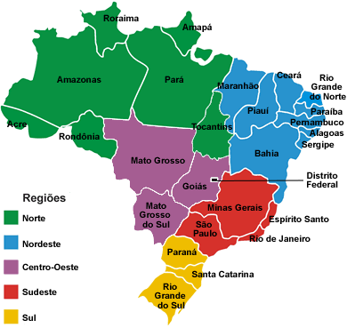
The Equatorial line cuts through the State of Amapa, in the North.
The Tropic of Capricorn line cuts through the State of Sao Paulo.
Rio Grande do Sul, the southernmost Brazilian State, is as far to the south as Houston, TX, is to the North; also for comparison: the entire European continent is further to the north than Rio Grande do Sul is to the south.
|
Click on the map or one of the links below.
Acre
(AC)
Alagoas
(AL)
Amapá
(AP)
Amazonas
(AM)
Bahia
(BA)
Brasília
(DF)
Ceará
(CE)
Espírito Santo
(ES)
Goiás
(GO)
Mato Grosso
(MT)
Mato Grosso do Sul
(MS)
Maranhão
(MA)
Minas Gerais
(MG)
Pará
(PA)
Paraná
(PR)
Paraíba
(PB)
Pernambuco
(PE)
Piauí
(PI)
Rio de Janeiro
(RJ)
Rio Grande do Norte
(RN)
Rio Grande do Sul
(RS)
Rondônia
(RO)
Roraima
(RR)
Santa Catarina
(SC)
São Paulo
(SP)
Sergipe
(SE)
Tocantins
(TO)
|